


Weather blog: Second day of flash flood warnings issued for El Paso, Teller counties
Emily Bejarano/The Gazette
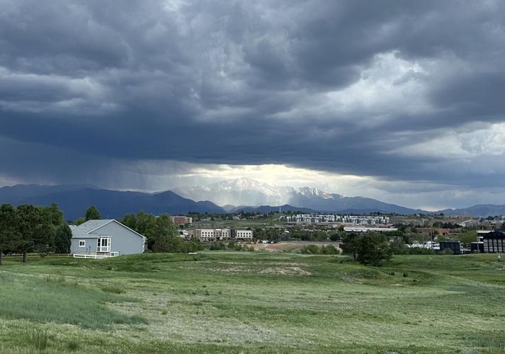
Clouds loom over Pikes Peak on a cloudy and rainy spring day in Colorado Springs.
Emily Bejarano/The Gazette

The National Weather Service in Pueblo on Wednesday announced a second day of flash flood warnings, following an eight-hour flood warning on Tuesday. The flood warnings are in effect in El Paso and Teller counties until 10 p.m.
The weather service put out an emergency alert at 3:10 p.m. that deems the flood risk a “dangerous and life-threatening situation.”
The city of Manitou Springs issued a news release Wednesday that warns of a second day of rainfall, mostly impacting high-elevation and foothill communities like Woodland Park, Monument Ridge, Peterson Space Force Base, Colorado Springs and Manitou Springs.
The Manitou Springs Fire Department issued a flood warning around 3:30 p.m., warning residents of 2 to 3 inches of rainfall expected by this evening.
Manitou Springs officials evacuated City Hall, the Manitou Springs Pool and Fitness Center and the Mobility Office at 202 Manitou Ave., and all nonessential city staff were sent home.
Residents of Pikes Peak RV Park and Green Willow Cottages were evacuated to Manitou Springs Middle School, city officials said. As of 5 p.m., officials said evacuations had been lifted and residents were allowed to return to their homes.
Routes 3, 33 and 36 of Mountain Metro Transit were delayed and rerouted and have since resumed regular service.
Manitou’s officials warn residents to stay away from burn scars, as the soil is less absorbent, increasing the potential for flash flooding, mudslides and rockslides.

A news graphic detailing a flash flood warning issued for El Paso and Teller counties until 10 p.m. on July 30, 2025.
Courtesy of the National Weather Service in Pueblo.

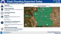
A news graphic detailing a flash flood warning issued for El Paso and Teller counties until 10 p.m. on July 30, 2025.
The National Weather Service issued several flash flood warnings on Wednesday, including for Colorado Springs, Manitou Springs, Monument, Palmer Lake and the Broadmoor neighborhood until 6:15 p.m.
Flash Flood Warning including Colorado Springs CO, Manitou Springs CO and Broadmoor CO until 6:15 PM MDT pic.twitter.com/atA7cCZdKg
— NWS Pueblo (@NWSPueblo) July 30, 2025
An additional special weather statement was issued by the weather service for Colorado Springs, Security and Fountain until 4 p.m., warning of 50 mph winds and hail up to half an inch.
Earlier on Wednesday, the weather service issued a severe thunderstorm warning for Black Forest and Monument until 3:15 p.m., and a tornado warning for Custer County until 3:45 p.m.
A tornado reportedly touched down in Custer County near Westcliffe, but was in an open field and the only damage was to a telephone pole, according to the weather service. No residents surrounding the area lost power, according to the Custer Public Power District.
DHSEM Area Field Manager is supporting damage assessments following tornadoes reported touching down near Westcliffe. https://t.co/N4BajSWqsU
— CO – Emergency Mgmt (@COEmergency) July 30, 2025
The high moisture around El Paso County is accompanied by a monsoon plume, according to the weather service, which is a stream of moisture coming from the gulf and Pacific Ocean as part of the North American Monsoon pattern.
The plume is causing higher humidity and heightened rainfall in the area. On Tuesday, the highest dew point of the day was 61 degrees, and Wednesday’s was 54 degrees. These high dew points that accompany monsoon plumes indicate high humidity and a muggy feeling in the air.
The monsoon in the Springs typically begins in early July, but can start as early as mid-June or as late as mid-July. The weather service says Colorado Springs is well into its monsoon season.
Monsoon moisture will continue to bring a risk of heavy rainfall with slow moving thunderstorms again this afternoon. The greatest risk for Flash Flooding will be across the Eastern mountains into the I-25 Corridor, with storms continuing east across the plains. #cowx pic.twitter.com/0wOA5OONLX
— NWS Pueblo (@NWSPueblo) July 30, 2025
So far in July, 1.13 inches of rain has fallen in Colorado Springs, which is less than the average of 2.89 inches. In July 2024, about 3.05 inches of rain fell in the Springs.
Colorado Springs has received 9.52 inches of rainfall this year, .48 less than the average of 10 inches at this time in past years.
The forecast
Wednesday’s high is 83 degrees with an 80% chance of thunderstorms from afternoon into the night. The Weather Service predicts that 0.5 to 0.75 inches of rain will fall.
Thursday’s forecast consists of all-day thunderstorms, with a 20% chance in the morning, an 80% chance in the afternoon and a 60% chance in the evening. The high will be 76 degrees and the nighttime low will be around 55 degrees.
Friday has a high of 80 degrees with a 60% chance of afternoon thunderstorms. The nighttime low will be around 54 degrees with a 30% chance of thunderstorms.
[related_articles]
PREV
PREVIOUS
Colorado Springs weather: Sunny Wednesday morning then afternoon thunderstorms and flood watch
Facebook Twitter WhatsApp SMS Email Print Copy article link Save The Pikes Peak Region will see sunny skies on Wednesday morning with a high of 81 and a chance for afternoon thunder storms and potential flood watch. “A cold front sweeping across the Plains this morning is bringing some strong north wind gusts to parts […]

Colorado Springs weather: Mostly sunny Thursday morning then chance of afternoon thunderstorms
Facebook Twitter WhatsApp SMS Email Print Copy article link Save Facebook Twitter WhatsApp SMS Email Print Copy article link Save Thursday will be partly sunny in Colorado Springs with a high of 80 and a 60% chance of afternoon thunderstorms and rain, mainly after 5 p.m. After a busy Wednesday, the monsoon patterns continue into […]